[返回博客](/cn/blog) # 在BimRv SDK中使用地形曲面(第2部分,共3部分)
Evgeniy Tikhonov 三月 05, 2020 [\#rfa](/cn/blog/tag/rfa) [\#rvt](/cn/blog/tag/rvt)
本文提供了创建和修改地形曲面的代码示例。有关本系列的第一篇文章和更多介绍性信息,请点击[此处](https://www.opendesign.com/blog/2019/december/working-topography-surfaces-bimrv-sdk-part-1-3)。
##### 使用点和面示例
以下代码演示了如何使用 OdBmSiteSurfaceHelper 类通过点和面设置曲面。
```
#include "Database/BmTransaction.h"
#include "Main/BmSiteSurfaceHelper.h"
OdGePoint3dArray points;
points.push_back(OdGePoint3d(19857.25, 20260.45, 100.30));
points.push_back(OdGePoint3d(20249.13, 19884.37, 101.09));
points.push_back(OdGePoint3d(21330.37, 20345.12, 87.97));
points.push_back(OdGePoint3d(19657.43, 21044.29, 97.83));
points.push_back(OdGePoint3d(19917.07, 21296.76, 98.19));
points.push_back(OdGePoint3d(20257.67, 21004.94, 97.36));
points.push_back(OdGePoint3d(20567.17, 21652.50, 98.46));
points.push_back(OdGePoint3d(21403.69, 21134.81, 90.62));
OdArray facets;
OdUInt16Array facet;
#define MAKE_FACET(V1, V2, V3) \
facet.clear(); \
facet.push_back(V1); facet.push_back(V2); facet.push_back(V3); \
facets.push_back(facet);
MAKE_FACET( 5, 3, 0 )
MAKE_FACET( 5, 4, 3 )
MAKE_FACET( 0, 1, 5 )
MAKE_FACET( 5, 2, 7 )
MAKE_FACET( 2, 5, 1 )
MAKE_FACET( 7, 6, 5 )
MAKE_FACET( 5, 6, 4 )
#undef MAKE_FACET
OdBmDatabasePtr pDb = app->readFile(L"empty_project.rvt");
OdBmSiteSurfacePtr pSurf = OdBmSiteSurface::createObject();
ODBM_TRANSACTION_BEGIN(t, pDb)
t.start();
pDb->addElement(pSurf);
OdBmSiteSurfaceHelper helper(pSurf);
// sets the surface using points and faces, the surface prohibits modifications
helper.setSurface(points, facets);
OdGePoint3dArray deleted;
deleted.push_back(points[3]);
OdResult res;
res = helper.deletePoints(deleted); // res == eNotApplicable
res = helper.movePoints(helper.getPoints(), moveVector); // res == eNotApplicable
res = helper.changePointElevation(OdGePoint3d(points.first().x, points.first().y, 10.), pt.z); // res == eNotApplicable
res = helper.changePointElevation(OdGePoint3d(points.last().x, points.last().y, 10.), pt.z + 10.); // res == eNotApplicable
helper.applyToSurface();
t.commit();
ODBM_TRANSACTION_END()
```
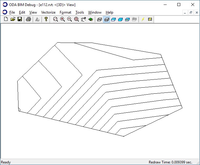
由这些点和面构建的地形曲面图:
##### 仅使用点示例
下一个示例演示了仅使用点设置曲面。
```
#include "Database/BmTransaction.h"
#include "Main/BmSiteSurfaceHelper.h"
OdGePoint3dArray points;
points.push_back(OdGePoint3d(19857.25, 20260.45, 100.30));
points.push_back(OdGePoint3d(20249.13, 19884.37, 101.09));
points.push_back(OdGePoint3d(21330.37, 20345.12, 87.97));
points.push_back(OdGePoint3d(19657.43, 21044.29, 97.83));
points.push_back(OdGePoint3d(19917.07, 21296.76, 98.19));
points.push_back(OdGePoint3d(20257.67, 21004.94, 97.36));
points.push_back(OdGePoint3d(20567.17, 21652.50, 98.46));
points.push_back(OdGePoint3d(21403.69, 21134.81, 90.62));
OdBmDatabasePtr pDb = app->readFile(L"empty_project.rvt");
OdBmSiteSurfacePtr pSurf = OdBmSiteSurface::createObject();
ODBM_TRANSACTION_BEGIN(t, pDb)
t.start();
pDb->addElement(pSurf);
OdBmSiteSurfaceHelper helper(pSurf);
// sets the surface using only points, the surface allows modifications
helper.setSurface(points);
OdGePoint3dArray deleted;
deleted.push_back(points[3]);
OdResult res;
res = helper.deletePoints(deleted); // res == eOk
res = helper.movePoints(helper.getPoints(), moveVector); // res == eOk
res = helper.changePointElevation(OdGePoint3d(points.first().x, points.first().y, 10.), pt.z); // res == eOk
res = helper.changePointElevation(OdGePoint3d(points.last().x, points.last().y, 10.), pt.z + 10.); // res == eOk
helper.applyToSurface();
t.commit();
ODBM_TRANSACTION_END()
```
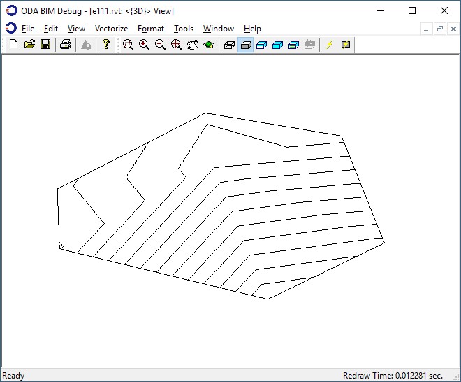
由这些点构建的地形曲面图以及对曲面应用更改后的结果。
本系列的下一篇文章将展示如何从 .Json 文件加载曲面的示例。
## 今天就开始行动
**免费试用 ODA 软件 60 天。
无风险,无需信用卡。**
[免费试用](https://www.opendesign.com/cn/free-trial)